How to identify WEAK satellite tracks on photos
metop_abrixas
metop_a_and_abrixas_traces
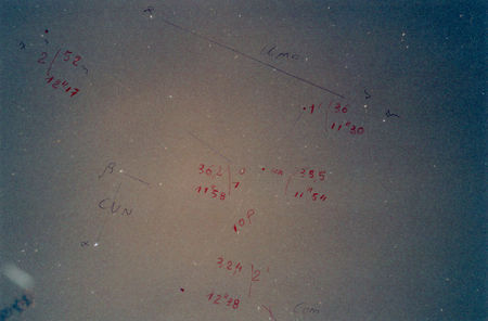
Sometimes we got weak or short track lines on photos and the chopping of the line enabling to get the time elapsed is hardly perceptible. See photo here after(Canes venatici CVN) and ground track on 5 April 07, 22H21(2), where we got by chance two weak tracks crossing.
1) We lengthened with a pencil at first the two track photos and on the extensions we materialized two points near bright stars to get RA, D of these points.
2) We chose arbitrarily a height of 650 kms and computed then the time between these two points and got finally inclination, nodes and zenithal ascending transit ZAT.(see REVOSAT)
3) Relevant to track 1->2,we got inclination 99°,ZAT=22H 39 (2) and of course 650kms
4) We suspected 1->2 being METOP-A but the published ZAT of METOP-A is taking place at 22H43(2) every day (Heliosynchronous).
5) We computed time again with height=815kms(Data of Metop-A published by Heavens above) instead of 650kms.We got 99°,ZAT=22H43(2) and of course 815 kms. We computed height max and got 62° .(See REVOSAT )These values are exactly those published by Heavens above on 5 April 07. The satellite 1->2 is really METOP-A.
6) We used the same method with track 1’->2’.We got an inclination of 48.5 °.It is Abrixas the only one to have such an inclination.
7) Conclusion. We got a cloudy photo and then nevertheless identified the two tracks.


/https%3A%2F%2Fassets.over-blog.com%2Ft%2Fcedistic%2Fcamera.png)